
The low-pressure area that has been lingering west-northwest of American Samoa for several days has organized into a tropical depression.
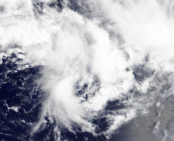
The low-pressure area that has been lingering west-northwest of American Samoa for several days has organized into a tropical depression. NASA’s Terra satellite passed over the Southern Pacific Ocean and provided forecasters with a visible image of Tropical Depression 18P.
On Feb.21, the Moderate Resolution Imaging Spectroradiometer or MODIS instrument that flies aboard NASA’s Terra satellite provided a visible image of 18P that showed an improved cyclonic circulation along the southern end of a line of deep convection and thunderstorms that extends north-to-south.
At 10 a.m. EST (1500 UTC) on Feb. 21, the Joint Typhoon Warning Center said Tropical Cyclone 18P had maximum sustained winds near 30 knots (34.5 mph/55.5 kph). It was located near latitude 12.9 degrees south and longitude 174.8 degrees west, about 280 nautical miles west-northwest of Pago Pago, American Samoa. 18P is moving to the east-southeast.
The tropical cyclone is forecast to intensify to a tropical storm reaching maximum sustained winds to 45 knots as it passes near American Samoa on Feb. 22. In three days, vertical wind shear is expected to kick in which will cause the storm to dissipate quickly.
Read more at NASA/Goddard Space Flight Center
Image: On Feb. 21, 2020, the MODIS instrument that flies aboard NASA's Terra satellite provided a visible image of newly developed Tropical Depression 18P in the Southern Pacific Ocean. (Credit: NASA Worldview)


