
Flights were grounded as visibility was severely hampered by a Calima event.
In late February 2020, strong Saharan winds picked up dust from Africa and carried it over the Canary Islands, severely reducing visibility and disrupting travel by land and air. Some public officials described it as the worst sandstorm in decades.
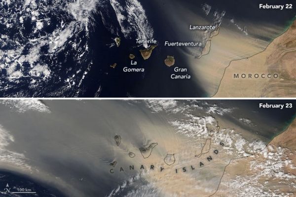
The Moderate Resolution Imaging Spectroradiometer (MODIS) on NASA’s Terra and Aqua satellites acquired these natural-color images of the storm on February 22 and 23, 2020. Gran Canaria, Fuerteventura, and Lanzarote appeared to be hardest hit by the storm, which started abruptly on February 22 and continued as rain clouds started to roll in on the 24th. (See this time-lapse animation.) Visibility was reduced to tens of meters in some places.
Such dust events, known to islanders as “La Calima,” typically last several days. They are provoked by hot, dry southeasterly or easterly winds blowing out from Morocco and Western Sahara, and they are sometimes associated with the Saharan air layer. Calima storms turn the skies orange or red over the island chain.
Due to strong winds—with gusts up to 120 kilometers (75 miles) per hour—and poor visibility, all airports across the Canary Islands were closed on February 22 and most stayed closed until February 24. Close to 800 flights were cancelled or re-routed. Some roads were also shut down due to limited visibility.
Continue reading at NASA Earth Observatory
Image via NASA Earth Observatory


