
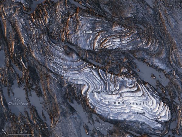
The striking patterns in northeastern Canada’s flood basalts tell a story of continental collisions that played out almost two billion years ago.
During the last Ice Age, advancing and retreating glaciers in northeastern Canada scraped the surface clean of debris to help make visible some stunning fold patterns in the basaltic rock. Those folds are still visible today and appear in these images, which show part of a geologic belt called the New Quebec Orogen (also known as the Labrador Trough).
The orogen stretches southeast from Ungava Bay through Quebec and Labrador, with striking geologic features throughout. These images highlight the deformation in Earth’s crust just east of the Caniapiscau River. The images were acquired on February 13, 2020, by the Operational Land Imager (OLI) on Landsat 8, and were overlaid on a digital elevation model from the Shuttle Radar Topography Mission (SRTM) to give a sense of the topography. Wintertime snow and ice blanket some of the landscape.
“The patterns shown in the images have quite a long history—from rifting to cooling to folding—during continental collision,” said Deanne van Rooyen, a geologist at Cape Breton University who has studied the region. About 2.17 billion years ago, she explained, molten rock erupted from rifts in Earth’s crust and flooded the landscape with basalt. Successive flows of this so-called “flood basalt” were laid down in nearly horizonal layers, producing the step-like pattern visible in these images. When viewed up close, most flows show spectacular columnar jointing structures.
Continue reading at NASA Earth Observatory
Image via NASA Earth Observatory


