
NASA-NOAA’s Suomi NPP satellite provided forecasters with a visible image ex-tropical cyclone Esther’s remnant clouds that have now moved over Australia’s Northern Territory.
NASA-NOAA’s Suomi NPP satellite provided forecasters with a visible image ex-tropical cyclone Esther’s remnant clouds that have now moved over Australia’s Northern Territory. The remnants have generated a flood watch including in the Tanami and Central Deserts.
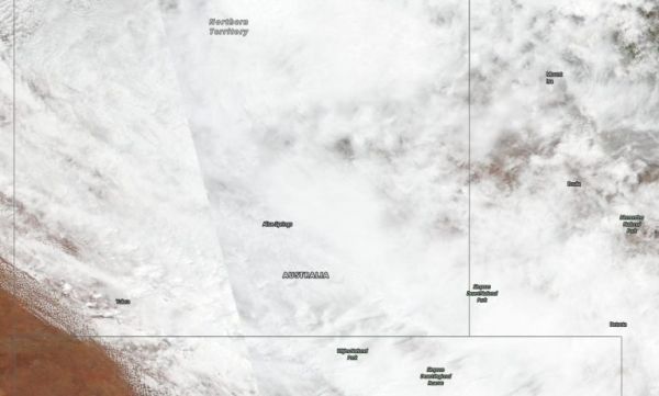
Visible imagery from satellites help forecasters understand if a storm is organizing or weakening and the extent and movement of the storm. The Visible Infrared Imaging Radiometer Suite (VIIRS) instrument aboard Suomi NPP provided an image on Mar. 3 that showed the remnant clouds and storms associated with the ex-tropical cyclone have blanketed the Northern Territory. The center of ex-tropical cyclone Esther is located over the northern Tanami District.
On March 3, the Australian Bureau of Meteorology (ABM), Northern Territory issued a Flood Watch for the Tanami Desert, Central Desert, MacDonnell Ranges, Barkly, Georgina River and Simpson Desert. A flood warning was in effect for Sturt Creek District in Western Australia.
Read more at NASA / Goddard Space Flight Center
Image: NASA-NOAA’s Suomi NPP satellite provided an image on Mar. 3, 2020 that showed the remnant clouds and storms associated with ex-tropical cyclone Esther have blanketed the Northern Territory. Credit: NASA Worldview, Earth Observing System Data and Information System (EOSDIS)


