
NASA’s Terra satellite passed over the Southern Indian Ocean and provided forecasters with a visible image of Ex-Tropical Cyclone 21S.
NASA’s Terra satellite passed over the Southern Indian Ocean and provided forecasters with a visible image of Ex-Tropical Cyclone 21S. Although no longer a tropical cyclone, the system has triggered warnings for heavy rainfall and winds.
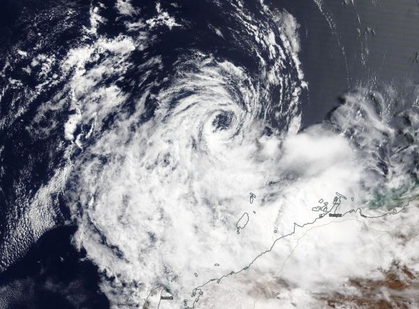
Tropical cyclone 21S was along the Pilbara coast. The Pilbara Coast is also known as the northwest coast of Western Australia.
The final warning from the Joint Typhoon Warning Center (JTWC) on 21S as a tropical system came on Mar. 11 at 5 p.m. EDT (2100 UTC). At the time, it had maximum sustained winds near 35 knots (64 kph/40 mph) and was moving to the southwest and toward the coast of Western Australia.
On March 12, the Moderate Resolution Imaging Spectroradiometer or MODIS instrument that flies aboard NASA’s Terra satellite provided a visible image of 21S that showed the storm affecting the states of Gascoyne and Pilbara. The image showed the low-level circulation center still offshore and the bulk of clouds and precipitation over Western Australia.
Read more at NASA/Goddard Space Flight Center
Image: On Mar. 12, 2020, the MODIS instrument that flies aboard NASA's Terra satellite provided a visible image of Ex-Tropical Cyclone 21S, affecting Western Australia's Pilbara coast. (Credit: NASA Worldview)


