
One year ago, a historic flood struck Nebraska, topping levees; taking out bridges, dams and houses; covering thousands of acres in water; and reminding Nebraskans of the power of a raging river.
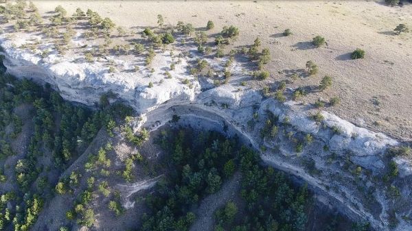
But destructive floods in Nebraska’s ancient past have also shaped the state’s geology, forming bouldery rocks in the rim of the Wildcat Ridge of western Nebraska, finds a recent study by University of Nebraska–Lincoln researchers.
The boulders — some the size of a smart car and formed about 23 million years ago — were first documented in 1903 by geologist Nelson Horatio Darton. But they were difficult to study due to their location about 300 feet up extreme terrain, said Jesse Korus, geologist with the Conservation and Survey Division at Nebraska. That changed when Korus got his drone license in 2017, making it possible for the survey division to conduct an in-depth, detailed study of the rocks for the first time.
Over the course of a year, the team of researchers took more than 3,000 drone photographs of the geologic formation known as the Haystack Mountain conglomerate. From the photographs, they constructed 3-D representations of the cliffs, or digital outcrop models.
“We also used ground-penetrating radar, which allowed us to see under the ground behind the cliffs, further enhancing our 3-D reconstruction of the rock structures,” Korus said.
Continue reading at University of Nebraska Lincoln
Image via University of Nebraska Lincoln


