
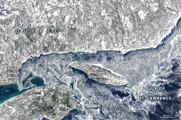
Winds and currents stirred up the thin sea ice, forming delicate patterns around Anticosti Island in Quebec, Canada.
The planet’s oceans are constantly in motion, but the movement is not always easy to see from space. Sometimes colorful sediment and phytoplankton act as tracers, detailing the path of currents and eddies. In colder months, the swirling patterns are sometimes traced by sea ice.
On March 9, 2020, the Moderate Resolution Imaging Spectroradiometer (MODIS) on NASA’s Aqua satellite acquired this image of sea ice and eddies in the northwestern Gulf of St. Lawrence. The ice was thin enough at the time to be moved around by winds and currents, forming delicate patterns around Anticosti Island in Quebec, Canada.
You can see the motion in the video below, which spans most of the daylight hours on March 9. The video uses imagery from the Advanced Baseline Imager (ABI) on GOES 16 (GOES-East). GOES satellites are operated by the National Oceanic and Atmospheric Administration (NOAA); NASA helps develop and launch them.
Continue reading at NASA Earth Observatory
Image via NASA Earth Observatory


