
NASA’s Terra satellite passed over the Southern Pacific Ocean and captured an image of Tropical Storm Gretel as it was transitioning into an extra-tropical cyclone, northwest of New Zealand.
NASA’s Terra satellite passed over the Southern Pacific Ocean and captured an image of Tropical Storm Gretel as it was transitioning into an extra-tropical cyclone, northwest of New Zealand.
Tropical Cyclone 23P formed on March 14 at 4 p.m. EDT (2100 UTC) between Australia and New Caledonia. Once it intensified into a tropical storm, it was renamed Gretel.
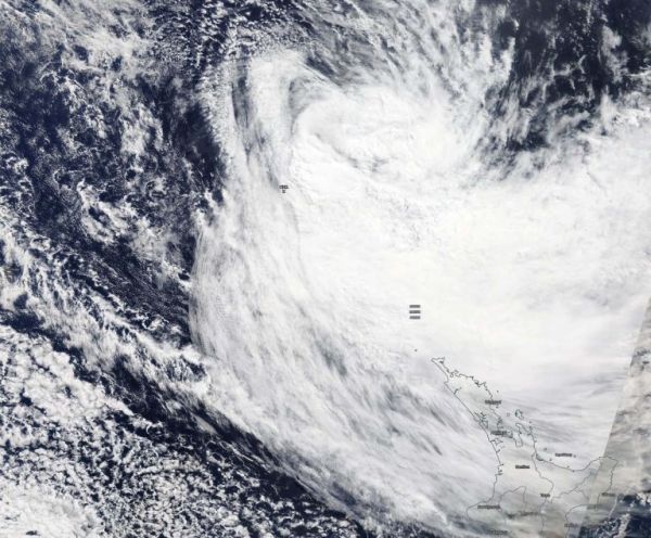
On March 16, the Moderate Resolution Imaging Spectroradiometer or MODIS instrument that flies aboard NASA’s Terra satellite provided forecasters with a visible image of Tropical Cyclone Gretel. The bulk of Gretel’s clouds and storms were south and southeast of the center of circulation. Clouds associated with Gretel extended to northern New Zealand, despite the storm’s center being hundreds of miles away.
At 11 p.m. EDT on March 15 (0300 UTC on March 16), the Joint Typhoon Warning Center or JTWC issued the final warning on Gretel. At that time, the center of Tropical Cyclone Gretel was located near latitude 26.6 degrees south and longitude 169.7 degrees east, about 675 nautical miles north-northwest of Auckland, New Zealand. Maximum sustained winds were near 50 knots (58 mph/93 kph) and Gretel was speeding southeast at 25 knots (29 mph/46 kph).
Read more at NASA/Goddard Space Flight Center
Image: On March 16, the MODIS instrument that flies aboard NASA’s Terra satellite took this image of Tropical Cyclone Gretel and showed a transitioning storm northwest of New Zealand. Credit: NASA Worldview


