
When NASA’s Aqua satellite passed over the Southern Indian Ocean on Mar. 18, it gathered water vapor data that showed wind shear was adversely affecting Tropical Cyclone Herold.
When NASA’s Aqua satellite passed over the Southern Indian Ocean on Mar. 18, it gathered water vapor data that showed wind shear was adversely affecting Tropical Cyclone Herold.
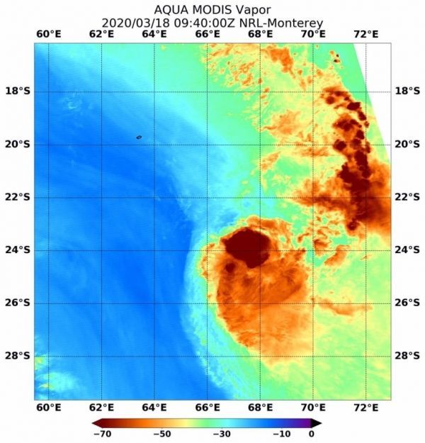
In general, wind shear is a measure of how the speed and direction of winds change with altitude. Tropical cyclones are like rotating cylinders of winds. Each level needs to be stacked on top each other vertically in order for the storm to maintain strength or intensify. Wind shear occurs when winds at different levels of the atmosphere push against the rotating cylinder of winds, weakening the rotation by pushing it apart at different levels. Strong wind shear from the northwest is battering Herold and pushing the strongest storms away from the center of circulation. Northwesterly winds affecting the storm are estimated between 25 and 30 knots (29 to 35 mph /46 to 56 kph)
What Water Vapor Reveals
NASA’s Aqua satellite passed over Tropical Cyclone Herold on Mar. 18 at 5:40 a.m. EDT (0940 UTC) and the Moderate Resolution Imaging Spectroradiometer or MODIS instrument gathered water vapor content and temperature information. The MODIS data showed highest concentrations of water vapor and coldest cloud top temperatures were pushed about 48 nautical miles southeast of the center of circulation.
Read more at NASA / Goddard Space Flight Center
Image: On Mar. 18 at 5:40 a.m. EDT (0940 UTC), NASA’s Aqua satellite passed over Tropical Cyclone Herold, located in the Southern Indian Ocean. Aqua found highest concentrations of water vapor (brown) and coldest cloud top temperatures were south of the center. Credits: NASA/NRL


