
Severe flooding throughout the Midwest—which triggered a delayed growing season for crops in the region—led to a reduction of 100 million metric tons of net carbon uptake during June and July of 2019, according to a new study.
Severe flooding throughout the Midwest—which triggered a delayed growing season for crops in the region—led to a reduction of 100 million metric tons of net carbon uptake during June and July of 2019, according to a new study.
For reference, the massive California wildfires of 2018 released an estimated 12.4 million metric tons of carbon into the atmosphere. And although part of this deficit due to floods was compensated for later in the growing season, the combined effects are likely to have resulted in a 15 percent reduction in crop productivity relative to 2018, the study authors say.
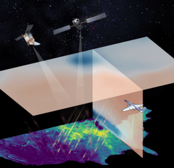
The study, published March 31, 2020, in the journal AGU Advances, describes how the carbon uptake was measured using satellite data. Researchers used a novel marker of photosynthesis known as solar-induced fluorescence to quantify the reduced carbon uptake due to the delay in the crops' growth. Independent observations of atmospheric CO2 levels were then employed to confirm the reduction in carbon uptake.
"We were able to show that it's possible to monitor the impacts of floods on crop growth on a daily basis in near real time from space, which is critical to future ecological forecasting and mitigation," says Yi Yin, research scientist at Caltech and lead author of the study.
Read more at California Institute Of Technology
Image: Researchers are using satellite and aircraft observations to monitor regional land carbon fluxes in near real-time, as illustrated in this artist's concept. Satellite observations of solar-induced chlorophyll fluorescence (SIF) were used to track photosynthesis and estimate corresponding changes in land surface carbon fluxes. Meanwhile, atmospheric CO2 concentrations, which are influenced by the land surface carbon fluxes, can be observed by aircraft and from space. In this illustration, the two satellites depicted from left to right are: TROPOMI (TROPOspheric Monitoring Instrument) and OCO-2 (Orbiting Carbon Observatory-2). The aircraft is the ACT-America (Atmospheric Carbon and Transport – America). CREDIT: California Institute of Technology


