
NASA analyzed the cloud top temperatures in the newly formed Tropical Cyclone Irondro using infrared light to determine where the strongest storms were located.
NASA analyzed the cloud top temperatures in the newly formed Tropical Cyclone Irondro using infrared light to determine where the strongest storms were located.
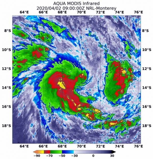
One of the ways NASA researches tropical cyclones is to use infrared data that provides temperature information. Cloud top temperatures identify where the strongest storms are located. The stronger the storms, the higher they extend into the troposphere, and the colder the cloud temperatures.
On April 2 at 5 a.m. EDT (0900 UTC), NASA’s Aqua satellite analyzed the storm using the Moderate Resolution Imaging Spectroradiometer or MODIS instrument imagery showed the strongest storms were west of the center of circulation. In that area, MODIS showed the coldest cloud top temperatures were as cold as or colder than minus 80 degrees Fahrenheit (minus 62.2 degrees Celsius). That strongest area of storms was surrounded by slightly less strong storms with cloud top temperatures as cold as minus 70 degrees Fahrenheit (minus 56.6 degrees Celsius) that extended in a band of thunderstorms to the south and southeast of the center. There was also a fragmented area of strong storms east of center. NASA research has shown that cloud top temperatures that cold indicate strong storms that have the capability to create heavy rain.
Read more at NASA / Goddard Space Flight Center
Image: On April 2 at 5 a.m., EDT (0900 UTC) NASA’s Aqua satellite analyzed the storm using the MODIS instrument. MODIS showed the strongest storms contained coldest cloud top temperatures (yellow) as cold as or colder than minus 80 degrees Fahrenheit (minus 62.2 degrees Celsius). That strongest area of storms was surrounded by slightly less strong storms (red) with cloud top temperatures as cold as minus 70 degrees Fahrenheit (minus 56.6C) that extended in a band of thunderstorms to the south and southeast of the center. Credit: NASA/NRL


