
Tropical Cyclone Harold brought heavy rains and hurricane-force winds to Vanuatu and was moving toward Fiji when NASA-NOAA’s Suomi NPP satellite provided forecasters with an image of the storm.
Tropical Cyclone Harold brought heavy rains and hurricane-force winds to Vanuatu and was moving toward Fiji when NASA-NOAA’s Suomi NPP satellite provided forecasters with an image of the storm.
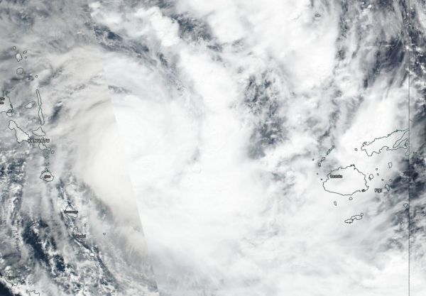
Visible imagery from NASA satellites help forecasters understand if a storm is organizing or weakening. The Visible Infrared Imaging Radiometer Suite (VIIRS) instrument aboard Suomi NPP provided a visible image of Harold on April 7, which showed the western quadrant of the storm east of Vanuatu while eastern quadrant was already affecting Fiji.
The shape of a tropical cyclone provides forecasters with an idea of its organization and strength, and NASA-NOAA’s Suomi NPP satellite showed powerful thunderstorms circling the low-level center of circulation with thick, fragmented bands of thunderstorms mostly on the eastern side of the storm. The eye was not visible on the Suomi NPP image. Forecasters at the Joint Typhoon Warning Center noted, “Animated enhanced infrared satellite imagery shows deep convection surrounding and obscuring the low level circulation center, possibly indicating an eye may be trying to form.”
Read more at NASA/Goddard Space Flight Center
Image: NASA-NOAA's Suomi NPP satellite provided forecasters with a visible image of Tropical Cyclone Harold on April 7 between Vanuatu (left) and Fiji (right). (Credit: NASA Worldview, Earth Observing System Data and Information System (EOSDIS))


