
One of NASA’s satellites that can measure the rate in which rainfall is occurring in storms passed over powerful Tropical Cyclone Harold just after it made landfall in Vanuatu in the Southern Pacific Ocean.
One of NASA’s satellites that can measure the rate in which rainfall is occurring in storms passed over powerful Tropical Cyclone Harold just after it made landfall in Vanuatu in the Southern Pacific Ocean.
Tropical Cyclone Harold developed from a low-pressure system that was observed to the east of Papua New Guinea last week, and has tracked to the southeast, where it has already caused flooding and loss of life in the Solomon Islands.
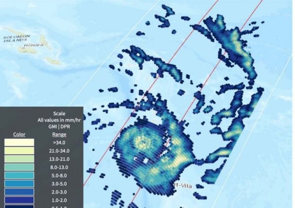
Now a Category 4 cyclone, the most powerful yet of 2020, Harold made landfall on the South Pacific nation of Vanuatu on Monday, April 6, not long before the Global Precipitation Measurement mission or GPM passed overhead. GPM’s Dual-frequency Precipitation Radar and GPM Microwave Imager data provided data on rainfall rates. “The highest rates were in the rain band to the southeast of the eye, at 48 mm (1.8 inches) per hour,” said B. Jason West, Science Data Analyst at NASA’s Goddard Space Flight Center in Greenbelt, Md. “Near the eye, rates in some areas also exceeded 40 mm (1.6 inches) per hour.”
Read more at NASA / Goddard Space Flight Center
Image: On April 6, 2020, the GPM satellite provided an estimate of rainfall rates in powerful Tropical Cyclone Harold over Vanuatu in the Southern Pacific Ocean. The highest rates were in the rain band to the southeast of the eye at 48 mm (1.8 inches) per hour. Near the eye rates in some areas also exceeded 40 mm (1.6 inches) per hr. Credit: JAXA/Jason West, NASA EOSDIS


