
On April 8, Tropical Cyclone Harold is a major hurricane, a Category 4 on the Saffir-Simpson Hurricane Wind Scale, as it exits Fiji and heads toward the island of Tonga.
On April 8, Tropical Cyclone Harold is a major hurricane, a Category 4 on the Saffir-Simpson Hurricane Wind Scale, as it exits Fiji and heads toward the island of Tonga. NASA used satellite data to calculate the rainfall generated by this powerful and destructive storm in the Southern Pacific Ocean.
Harold brought flooding rains and strong hurricane-force winds to the South Pacific island nation of Fiji on Wednesday, April 8. The Fiji Meteorological Service noted that Harold’s strength ranked in the highest category of five, when passed over Fiji’s south at about midday (local time). Earlier in the week, Harold caused damages and communications outages when it passed over Vanuatu on April 7, and killed dozens of people in the Solomon Islands.
Visualizing Harold’s Heavy Rainfall
At NASA’s Goddard Space Flight Center in Greenbelt, Maryland, the heavy rain generated from Harold from April 2 to 8 was calculated and mapped in an animation.
Read more at NASA / Goddard Space Flight Center
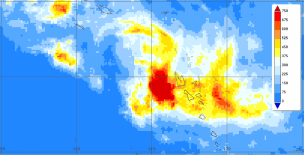
Image: This IMERG image estimates rainfall from March 30 to April 7 just west of Vanuatu in the South Pacific. The deeper red areas indicated rainfall totals up to almost 750 mm (30 inches) west and east of Vanuatu. Credit: NASA/JAXA, Steve Lang


