
The information of the territory provided by the laser technology from an airplane can be combined with data collected in mountain lakes with an inflatable boat and a small echo sounder to obtain three-dimensional maps.
The information of the territory provided by the laser technology from an airplane can be combined with data collected in mountain lakes with an inflatable boat and a small echo sounder to obtain three-dimensional maps. The system has been successfully tested by two geologists at the Truchillas glacial lake in Spain.
Scientists studying mountain lakes, often located in remote areas that are difficult to access, are faced with the problem of climbing with heavy and costly equipment. Helicopters are often essential.
But now, geologists Javier Fernández-Lozano, from the University of León (Spain), and Rodrigo Andrés-Bercianos, from the León Technology Park, have presented a very simple, low-cost methodology for obtaining high-resolution three-dimensional models of lake bottoms.
It only requires a 250-gram echo sounder and the so-called LiDAR detection data, which are collected from an airplane with laser technology. In the case of Spain, they are provided free of charge through the National Aerial Orthophotography Plan.
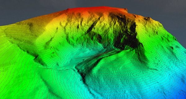
The new technique has been successfully implemented in the Truchillas Lake, of glacial origin, a natural monument of the Castile and León region located in the southwest of the province of León, and the results have been published in Quaternary International.
Read more at FECYT - Spanish Foundation For Science And Technology
Image: 3D map of the Lake Truchillas basin and Vizcodillo Peak (León). Credit: J. Fernández-Lozano/ R. Andrés-Bercianos


