
Machine learning algorithm uses high-resolution micro-satellite imagery and weather data to detect levels of harmful air pollution with as much accuracy and more resolution than any current method.
Researchers from Duke University have devised a method for estimating the air quality over a small patch of land using nothing but satellite imagery and weather conditions. Such information could help researchers identify hidden hotspots of dangerous pollution, greatly improve studies of pollution on human health, or potentially tease out the effects of unpredictable events on air quality, such as the breakout of an airborne global pandemic. The results appear online in the journal Atmospheric Environment.
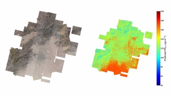
“We’ve used a new generation of micro-satellite images to estimate ground-level air pollution at the smallest spatial scale to date,” said Mike Bergin, professor of civil and environmental engineering at Duke. “We’ve been able to do it by developing a totally new approach that uses AI/machine learning to interpret data from surface images and existing ground stations.”
The specific air quality measurement that Bergin and his colleagues are interested in is the amount of tiny airborne particles called PM2.5. These are particles that have a diameter of less than 2.5 micrometers—about three percent of the diameter of a human hair—and have been shown to have a dramatic effect on human health because of their ability to travel deep into the lungs.
Continue reading at Duke University
Image via Duke University


