
A new stress map that reveals the forces acting on the planet’s crust will contribute to safer energy exploration, updated seismic hazard maps and improved knowledge about the Earth.
How do mountains form? What forces are needed to carve out a basin? Why does the Earth tremble and quake?
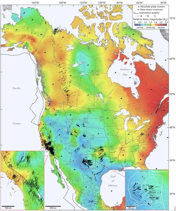
Earth scientists pursue these fundamental questions to gain a better understanding of our planet’s deep past and present workings. Their discoveries also help us plan for the future by preparing us for earthquakes, determining where to drill for oil and gas, and more. Now, in a new, expanded map of the tectonic stresses acting on North America, Stanford researchers present the most comprehensive view yet of the forces at play beneath the Earth’s surface.
The findings, published in Nature Communications on April 23, have implications for understanding and mitigating problems associated with induced seismicity – human-caused earthquakes – from unconventional oil and gas recovery, especially in Oklahoma, Texas and other areas targeted for energy exploration. But they also pose a whole new set of questions that the researchers hope will stimulate a wide range of modeling studies.
“Understanding the forces in the Earth’s crust is fundamental science,” said study co-author Mark Zoback, the Benjamin M. Page Professor of Geophysics in Stanford’s School of Earth, Energy & Environmental Sciences (Stanford Earth). “In some cases, it has immediate application, in others, it may be applied decades later to practical questions that do not exist today.”
Continue reading at Stanford University
Image via Stanford University


