
Researchers at the University of Miami (UM) Rosenstiel School of Marine and Atmospheric Science have uncovered a new connection between tropical weather events and U.S. rainfall during El Niño years.
Researchers at the University of Miami (UM) Rosenstiel School of Marine and Atmospheric Science have uncovered a new connection between tropical weather events and U.S. rainfall during El Niño years. The results can help explain why California received significantly less rainfall than predicted during the 2015 El Niño event while massive flooding occurred in the Mississippi River basin.
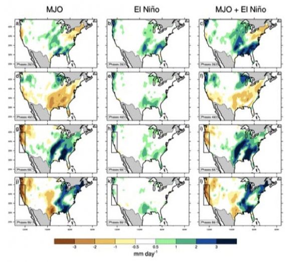
UM Rosenstiel School graduate student Marybeth Arcodia analyzed 39-years of weather data from the National Centers for Environmental Prediction–National Center for Atmospheric Research Reanalysis Project to understand how the Madden-Julian Oscillation (MJO), a phenomenon of sub-seasonal atmospheric variability in the tropical Indo-Pacific Oceans, leads to pressure and rainfall anomalies over the North Pacific and North America.
Results from the study show that when both an El Niño Southern Oscillation (ENSO) and MJO event are occurring simultaneously, the rainfall pattern typically seen from ENSO can be considerably altered for a few days to weeks due to interference from the MJO.
The researchers found that ENSO modifies the teleconnection signals associated with the Madden-Julian Oscillation in the United States. While at the same time, the El Niño Southern Oscillation acts to interfere with the MJO signals, resulting in significantly enhanced or masked rainfall anomalies in the U.S.
Read more at Rosenstiel School of Marine and Atmospheric Science
Image: Composites of CPC precipitation (millimeters/day) broken down by MJO phase from 1979 to 2017 for active MJO days in November–April during all El Niño (positive ENSO) days. The columns show (left) MJO-only rain, (center) ENSO-only rain, and (right) MJO + ENSO rain. CREDIT: By Diana Udel


