
NASA’s Terra satellite revealed powerful storms in Vongfong as it ramped up from a tropical storm to a typhoon.
NASA’s Terra satellite revealed powerful storms in Vongfong as it ramped up from a tropical storm to a typhoon. Vongfong is known locally in the Philippines as Typhoon Ambo.
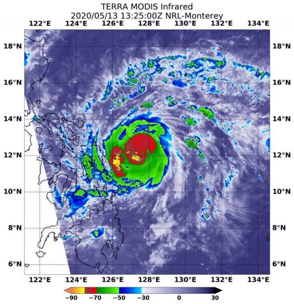
NASA’s Terra satellite used infrared light to analyze the strength of storms in Vongfong. Infrared data provides temperature information, and the strongest thunderstorms that reach high into the atmosphere have the coldest cloud top temperatures.
On May 13 at 9:25 a.m. EDT (1325 UTC), the Moderate Resolution Imaging Spectroradiometer or MODIS instrument aboard NASA’s Terra satellite gathered temperature information about Typhoon Vongfong’s cloud tops. MODIS found two large areas of powerful thunderstorms north and west of the center of circulation where temperatures were as cold as or colder than minus 70 degrees Fahrenheit (minus 56.6 Celsius). Cloud top temperatures that cold indicate strong storms with the potential to generate heavy rainfall.
Warnings in the Philippines include Tropical cyclone wind signal number #1 for the Visayas region: northern parts of Samar and northern parts of eastern Samar; and for the Luzon region: Sorsogon, Ticao Island, Catanduanes, southern parts of Albay.
Read more at NASA / Goddard Space Flight Center
Image: On May 13 at 9:25 a.m. EDT (1325 UTC), the MODIS instrument aboard NASA’s Terra satellite gathered temperature information about Typhoon Vongfong’s cloud tops. MODIS found two large areas of powerful thunderstorms (red) where temperatures were as cold as or colder than minus 70 degrees Fahrenheit (minus 56.6 Celsius). Credit: NASA/NRL


