
NASA and NOAA satellites have been providing forecasters with satellite data that showed the strength and extent of Typhoon Vongfong as it made landfall in the Philippines and continued to track through the country.
NASA and NOAA satellites have been providing forecasters with satellite data that showed the strength and extent of Typhoon Vongfong as it made landfall in the Philippines and continued to track through the country. Warnings were in effect throughout several areas of the Philippines on May 14.
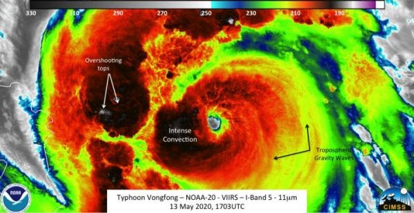
The NOAA-20 satellite saw Typhoon Vongfong at 12:03 p.m. EDT (1703 UTC) on May 13. “The imagery showed features that one would expect from an intensifying storm, including overshooting tops and tropospheric gravity waves,” said William Straka III of the University of Wisconsin- Madison, who created the imagery using the satellite data. “In addition, a clear eye could be seen as well.”
The infrared image also showed cloud top temperatures. Coldest cloud top temperatures are indicative of strongest storms because their cloud tops are pushed high into the atmosphere by strong uplift of air. NOAA-20 showed that the colder temperatures (where the convection is located) surrounds the circulation center, a sign of a mature tropical system.
The Visible Infrared Imaging Radiometer Suite (VIIRS) instrument aboard NASA-NOAA’s Suomi NPP satellite provided a visible image of Typhoon Vongfong as it was making landfall in the east central Philippines on May 14. Vongfong made landfall in Samar. Samar is the third largest island in the Philippines, and is located in eastern Visayas region.
Read more at NASA/Goddard Space Flight Center
Image: The NOAA-20 satellite saw Typhoon Vongfong at 12:03 p.m. EDT (1703 UTC) on May 13. The imagery showed features that's expected from an intensifying storm, including overshooting tops and tropospheric gravity waves. In addition, a clear eye could be seen as well. (Credit: NOAA/William Straka III, Univ. of Wisconsin Madison)


