
The third tropical cyclone of the Atlantic Ocean basin has been generating large amounts of rainfall over Mexico’s Yucatan and parts of Central America.
The third tropical cyclone of the Atlantic Ocean basin has been generating large amounts of rainfall over Mexico’s Yucatan and parts of Central America. Using satellite data, NASA analyzed that heavy rainfall and provided forecasters with valuable cloud top temperature data to help assess the strength of the storm.
On June 2, 2020, by 2 p.m. EDT, Tropical Depression 03L strengthened into Tropical Storm Cristobal over Mexico’s Gulf of Campeche. The Gulf of Campeche is surrounded by Mexico’s Yucatan Peninsula, and the gulf is part of the southwestern Gulf of Mexico.
Cristobal remained in the Bay of Campeche on June 3, and a Tropical Storm Warning remained in effect from Campeche to Puerto de Veracruz.
Analyzing Rainfall
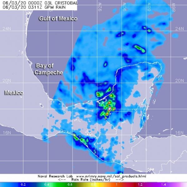
The Global Precipitation Measurement mission or GPM satellite provided a look at Cristobal’s rainfall rates on June 3 at 0311 UTC (June 2 at 11:11 p.m. EDT). GPM found heaviest rainfall south of center over Mexico’s Yucatan Peninsula, falling at rates of more than 1 inch (25 mm) per hour. Lighter rain rates appear around the entire system.
Read more at NASA / Goddard Space Flight Center
Image: GPM satellite provided a look at Cristobal’s rainfall rates on June 3 at 0311 UTC (June 2 at 11:11 p.m. EDT). GPM found heaviest rainfall south of center falling at rates of more than 1 inch (25 mm) per hour over Mexico’s Yucatan Peninsula. Lighter rain rates appear around the entire system. Credit: NASA/NRL


