
One of the ways NASA observes tropical cyclones is by using infrared data that provides temperature information and indicates storm strength.
One of the ways NASA observes tropical cyclones is by using infrared data that provides temperature information and indicates storm strength. The AIRS instrument aboard NASA’s Aqua satellite gathered that data and revealed Cristobal has the potential to generate heavy rainfall. That rainfall is now soaking Mexico and portions of Central America as Cristobal meanders.
At 9:35 a.m. EDT on Wednesday, June 3, Tropical Storm Cristobal made landfall in the Mexican state over Campeche, just to the west of Ciudad del Carmen. At the time of landfall, maximum winds were estimated to be 60 mph (95 kph) with higher gusts. Since landfall, Cristobal weakened to a depression, and moved very slowly in a southeasterly direction into northwestern Guatemala. As the storm weakened, it expanded, now heavy rainfall is expected in Mexico, Guatemala, El Salvador, Belize and Honduras.
Damaging and deadly flooding has already been occurring in portions of Mexico and Central America. Cristobal is expected to produce additional extreme rainfall amounts through the end of the week.
Read more at NASA / Goddard Space Flight Center
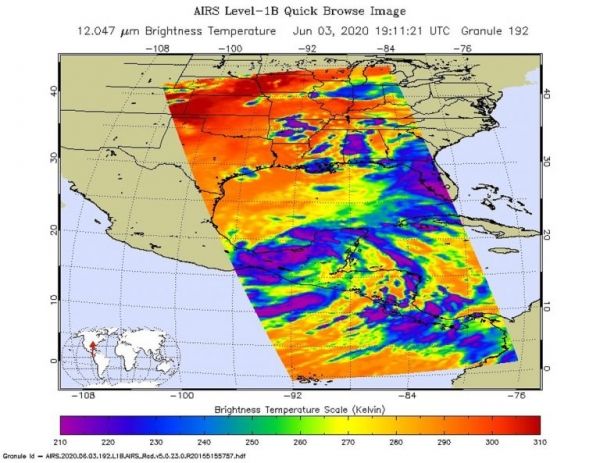
Image: On June 3 at 3:11 p.m. EDT (1911 UTC) NASA’s Aqua satellite analyzed Tropical Storm Cristobal using the Atmospheric Infrared Sounder or AIRS instrument. AIRS found coldest cloud top temperatures as cold as or colder than (purple) minus 63 degrees Fahrenheit (minus 53 degrees Celsius) east of center over Mexico’s Yucatan Peninsula. Credit: NASA JPL/Heidar Thrastarson


