
NASA’s Aqua satellite gathered infrared imagery and cloud top temperature data on Tropical Depression Cristobal, and it revealed the heavy rainmaking capability of the storm.
NASA’s Aqua satellite gathered infrared imagery and cloud top temperature data on Tropical Depression Cristobal, and it revealed the heavy rainmaking capability of the storm.
The National Hurricane Center (NHC) forecasts Cristobal to track northward through the Gulf of Mexico and toward Louisiana’s coast. Watches and warnings have gone into effect.
On June 5, the NHC issued a Storm Surge Watch for the northern Gulf of Mexico coast from Indian Pass to Arepika, Florida, and from Grand Isle, Louisiana, to Ocean Springs, Mississippi, including Lake Borgne. In addition, a Tropical Storm Watch has been issued for the northern Gulf of Mexico coast from Intracoastal City Louisiana to the Alabama/Florida border, including Lake Pontchartrain and Lake Maurepas.
Infrared Imagery and Cloud Top Temperatures
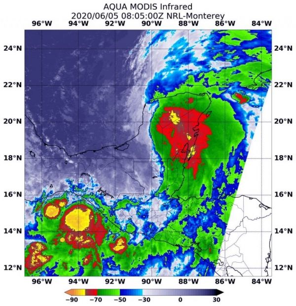
NASA’s Aqua satellite used infrared light to analyze the strength of storms in Cristobal. Infrared data provides temperature information, and the strongest thunderstorms that reach high into the atmosphere have the coldest cloud top temperatures. On June 5 at 4:05 a.m. EDT (0805 UTC), the Moderate Resolution Imaging Spectroradiometer or MODIS instrument aboard NASA’s Aqua satellite gathered temperature information about Cristobal’s cloud tops.
Read more at NASA / Goddard Space Flight Center
Image: On June 5 at 4:05 a.m. EDT (0805 UTC), the MODIS instrument aboard NASA’s Aqua satellite gathered temperature information about Tropical Depression Cristobal’s cloud tops. MODIS found several areas of powerful thunderstorms (yellow and red) where temperatures were as cold as or colder than minus 70 degrees Fahrenheit (minus 56.6 Celsius). Credit: NASA/NRL


