
Some landscapes can hold their own against climate change better than others.
Some landscapes can hold their own against climate change better than others. A study from the University of California, Davis, maps these places, called “climate refugia,” where existing vegetation is most likely to buffer the impacts of climate change through the end of the century.
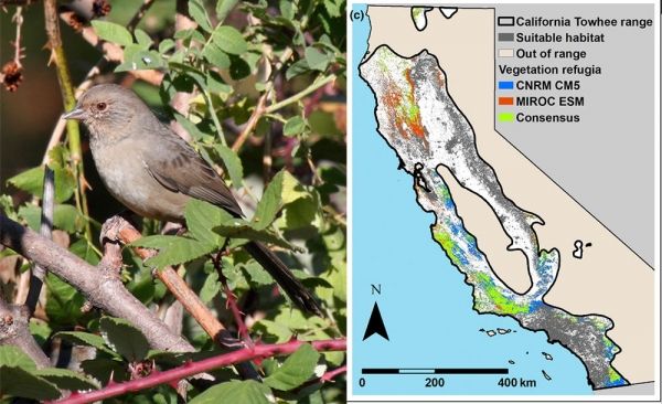
It found that about 15 percent of natural lands in California serve as climate refugia for the state’s plants, including trees, shrubs, annuals and perennials. The mapping tool can help natural resource managers prioritize and plan climate-adaptive management efforts, such as wildlife habitat conservation and post-wildfire restoration.
The study is published in a special issue of the journal Frontiers in Ecology and Evolution devoted to the theme of climate refugia. The issue and an accompanying website, climaterefugia.org, include other refugia related to fish and wildlife, rivers and wetlands, mountains and forests.
Read more at University Of California – Davis
Photo: Vegetation refugia maps can be used for wildlife conservation planning. For example, the study overlays the range of the California towhee, at left, with the refugia map to show suitable areas for the bird as the climate changes. (Photo by Andrew Engilis/UC Davis; map UC Davis)


