
Once a tropical storm in the Gulf of Mexico, now a tropical depression in the Mississippi Valley, NASA’s Aqua satellite is tracking Cristobal as it continues to generate large amounts of rainfall while it heads toward the Great Lakes region.
Once a tropical storm in the Gulf of Mexico, now a tropical depression in the Mississippi Valley, NASA’s Aqua satellite is tracking Cristobal as it continues to generate large amounts of rainfall while it heads toward the Great Lakes region.
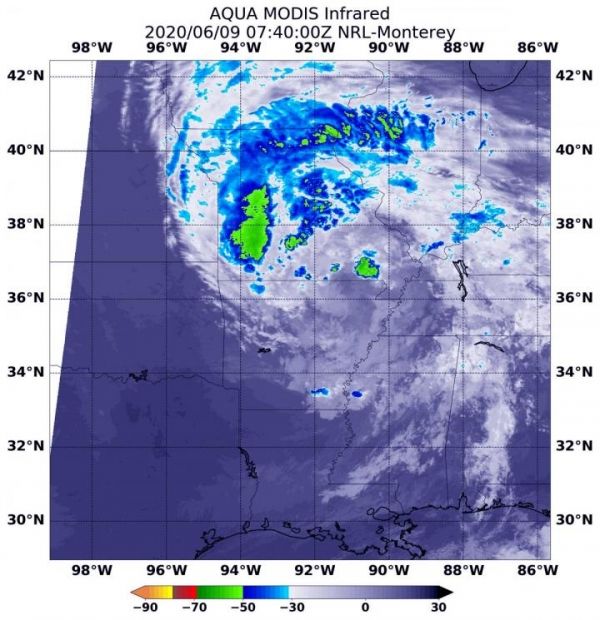
Infrared Data Reveals Strongest Storms
NASA’s Aqua satellite used infrared light to analyze the strength of storms and determine where the strongest storms were within the tropical depression. Strong storms are not evenly distributed within a tropical system, so it helps forecasters to know which side of the storm has the strongest storms and biggest rainmakers. Infrared data provides temperature information, and the strongest thunderstorms that reach high into the atmosphere have the coldest cloud top temperatures.
On June 9 at 3:40 a.m. EDT (0740 UTC) the Moderate Resolution Imaging Spectroradiometer (MODIS) instrument that flies aboard NASA’s Aqua satellite showed strongest storms in Tropical Depression Cristobal were northeast and north of the elongated center over western Missouri, Iowa and Illinois, where cloud top temperatures were as cold as minus 63 degrees Fahrenheit (minus 56.6 Celsius). NASA research has shown that storms with cloud top temperatures that cold have the ability to generate heavy rainfall.
Read more at NASA/Goddard Space Flight Center
Image: On June 9 at 3:40 a.m. EDT (0740 UTC) the MODIS instrument that flies aboard NASA's Aqua satellite showed strongest storms in Tropical Depression Cristobal were northeast and north of the elongated center over western Missouri, Iowa and Illinois, where cloud top temperatures were as cold as minus 63 degrees Fahrenheit (minus 56.6 Celsius). (Credit: NASA/NRL)


