
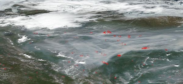
On June 21, 2020, NOAA/NASA's Suomi NPP satellite using the VIIRS instrument (Visible Infrared Imaging Radiometer Suite) captured this natural-color image of fires that have broken out across the Siberian section of Russia.
On June 21, 2020, NOAA/NASA's Suomi NPP satellite using the VIIRS instrument (Visible Infrared Imaging Radiometer Suite) captured this natural-color image of fires that have broken out across the Siberian section of Russia. The red dots that are spread across the landscape in the image are where the satellite has detected temperatures significantly higher than surrounding area. That combined with the smoke rising is indicator for fire. The VIIRS instrument which collected this image is a 22-band radiometer which collects infrared and visible light data to observe weather, climate, oceans, nightlight, wildfires, movement of ice, and changes in vegetation and landforms. Suomi NPP is the first Earth-observing satellite to measure both global climate changes and key weather variables. Suomi NPP is managed by NASA, NOAA and the U.S. Department of Defense.
Many outlets, including NASA, have reported that temperatures in the northernmost climes have have been running much higher than usual and the Siberian town of Verkhoyansk may have hit a record setting temperature of 100 degrees Fahrenheit. That is about 36 degrees F higher than the average temperatures in that area for June. Combining rising temperatures with the peat, underbrush, and grass that grows across much of the Siberian tundra, fires are more likely to break out and to spread. This year the fire season began weeks earlier than usual and fires that have broken out have been larger and more dangerous than in past seasons. This hot weather and the overabundance of fuel will provide the elements to ensure these wildfires will continue throughout the season, most likely.
Read more at NASA
Image Credit: NASA


