
The latest tropical storm in the Atlantic Ocean formed one day ago and was already being battered by wind shear.
The latest tropical storm in the Atlantic Ocean formed one day ago and was already being battered by wind shear. NASA’s Aqua satellite imagery revealed Tropical Storm Edouard’s strongest storms were being displaced by strong southwesterly winds.
Born on the fourth of July, the fifth tropical depression of the Atlantic Ocean hurricane season strengthened into a tropical storm and was renamed. At 11 p.m. EDT on July 5 (0300 UTC, July 6), Tropical Depression 5 strengthened into Tropical Storm Edouard.
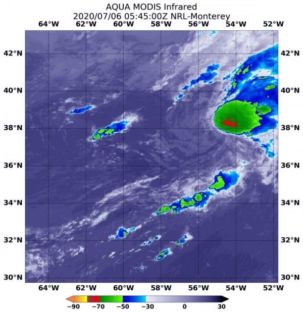
On July 6 at 1:45 a.m. EDT (0545 UTC), the MODIS instrument aboard NASA’s Aqua satellite analyzed Tropical Storm Edouard’s cloud tops in infrared light. Infrared data provides temperature information, and the strongest thunderstorms that reach high into the atmosphere have the coldest cloud top temperatures.
The Moderate Resolution Imaging Spectroradiometer or MODIS instrument aboard NASA’s Aqua satellite found a small area of powerful thunderstorms northeast of the center of circulation, where temperatures were as cold as or colder than minus 70 degrees Fahrenheit (minus 56.6 Celsius). Cloud top temperatures that cold indicate strong storms with the potential to generate heavy rainfall. Southwesterly wind shear was pushing the strongest storms northeast of the tropical cyclone’s center. Satellite imagery indicates that the rest of Edouard was comprised of an exposed swirl of low- to mid-level clouds.
Read more at NASA/Goddard Space Flight Center
Image: On July 6 at 1:45 a.m. EDT (0545 UTC), the MODIS instrument aboard NASA's Aqua satellite gathered temperature information about Tropical Storm Edouard's cloud tops. MODIS found a small area of powerful thunderstorms (red) where temperatures were as cold as or colder than minus 70 degrees Fahrenheit (minus 56.6 Celsius). MODIS also showed westerly wind shear was pushing the bulk of clouds northeast of the storm's center. (Credit: NASA/NRL)


