
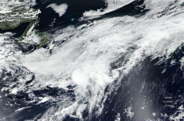
When NASA-NOAA’s Suomi NPP satellite passed over the western North Atlantic Ocean on July 6, it provided forecasters with a visible image of Edouard after it transitioned into a post-tropical cyclone.
When NASA-NOAA’s Suomi NPP satellite passed over the western North Atlantic Ocean on July 6, it provided forecasters with a visible image of Edouard after it transitioned into a post-tropical cyclone.
The National Hurricane Center (NHC) defines a post-tropical cyclone as a former tropical cyclone. This generic term describes a cyclone that no longer possesses sufficient tropical characteristics to be considered a tropical cyclone. Post-tropical cyclones can continue carrying heavy rains and high winds. Two classes of post-tropical cyclones include extratropical and remnant lows.
The Visible Infrared Imaging Radiometer Suite (VIIRS) instrument aboard Suomi NPP provided a visible image that showed Edouard’s center of circulation has merged with a frontal boundary. Therefore, the system was classified as extratropical.
On July 6 at 5 p.m. EDT (2100 UTC), NOAA’s National Hurricane Center (NHC) said that Edouard had become post-tropical. At that time, the center of Post-Tropical Cyclone Edouard was located near latitude 42.7 degrees north and longitude 46.0 degrees west. It was centered about 445 miles (715 km) southeast of Cape Race Newfoundland, Canada. The post-tropical cyclone was moving quickly toward the northeast near 38 mph (61 kph). Maximum sustained winds are near 45 mph (75 kph) with higher gusts. The estimated minimum central pressure is 1005 millibars.
Read more at NASA/Goddard Space Flight Center
Image: On July 6, NASA-NOAA's Suomi NPP satellite provided a visible image of Post-Tropical Cyclone Edouard merging with a frontal boundary in the Northern Atlantic Ocean. (Credit: NASA Worldview, Earth Observing System Data and Information System (EOSDIS))


