
NASA’s Aqua satellite used infrared light to identify the strongest storms and coldest cloud top temperatures in Tropical Depression 6E.
NASA’s Aqua satellite used infrared light to identify the strongest storms and coldest cloud top temperatures in Tropical Depression 6E. Aqua found a few small areas of strength but cooler sea surface temperatures are expected to weaken them.
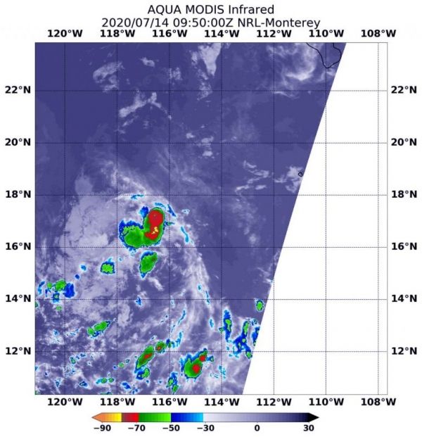
Tropical Depression 6E formed in the Eastern Pacific Ocean by 5 p.m. EDT on July 13 and was located well to the southwest of Baja California Sur, Mexico.
On July 14 at 5:50 a.m. EDT (0950 UTC), the Moderate Resolution Imaging Spectroradiometer or MODIS instrument aboard NASA’s Aqua satellite analyzed Tropical Depression 6E’s cloud tops in infrared light. Infrared data provides temperature information, and the strongest thunderstorms that reach high into the atmosphere have the coldest cloud top temperatures.
Aqua found the most powerful thunderstorms in several small, fragmented areas northeast, southeast and southwest of the center of circulation, where temperatures were as cold as or colder than minus 70 degrees Fahrenheit (minus 56.6 Celsius). Cloud top temperatures that cold indicate strong storms with the potential to generate heavy rainfall. Cloud top temperatures around the rest of the depression were warmer, indicating less-powerful storms.
Read more at NASA / Goddard Space Flight Center
Image: On July 14 at 5:50 a.m. EDT (0950 UTC), the MODIS instrument aboard NASA’s Aqua satellite gathered temperature information about Tropical Depression 6E’s cloud tops. MODIS found a few small areas of powerful thunderstorms (red) where temperatures were as cold as or colder than minus 70 degrees Fahrenheit (minus 56.6 Celsius). Credit: NASA/NRL


