
When NASA’s Aqua satellite passed over the Eastern Pacific Ocean, it gathered water vapor data on Tropical Depression 06E that showed it had opened up into a trough.
When NASA’s Aqua satellite passed over the Eastern Pacific Ocean, it gathered water vapor data on Tropical Depression 06E that showed it had opened up into a trough. A trough is an elongated area of low pressure.
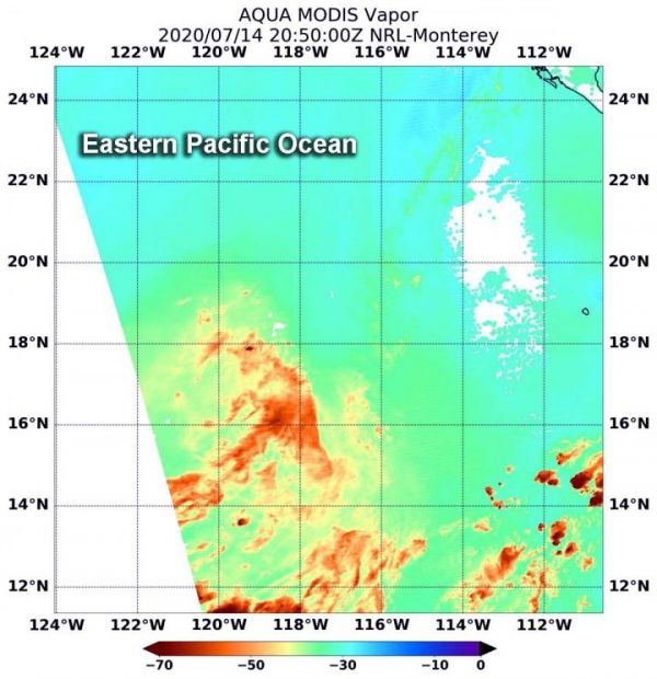
On July 14 at 4:50 p.m. EDT (2050 UTC), NASA’s Aqua satellite passed over the remnants of Tropical Depression 06E. The Moderate Resolution Imaging Spectroradiometer or MODIS instrument aboard Aqua gathered the water vapor content and temperature information. MODIS found minimal concentrations of water vapor and the circulation had opened up into a trough.
Water vapor analysis of tropical cyclones tells forecasters how much potential a storm has to develop. Water vapor releases latent heat as it condenses into liquid. That liquid becomes clouds and thunderstorms that make up a tropical cyclone. Temperature is important when trying to understand how strong storms can be. The higher the cloud tops, the colder and stronger the storms. TD6E showed very limited water vapor.
At 5 p.m. EDT on July 14, the National Hurricane Center (NHC) said a satellite overpass “indicated that the circulation of the tropical depression was no longer closed with light and variable winds evident on its south side. Therefore, the system no longer meets the criteria of a tropical cyclone.”
Read more at NASA/Goddard Space Flight Center
Image: On July 14 at 4:50 p.m. EDT (2050 UTC), NASA's Aqua satellite passed over the remnants of Tropical Depression 06E. The concentrations of water vapor (light brown) were minimal and the circulation had opened up into an elongated area of low pressure. (Credit: NASA/NRL)


