
Hurricane Lane was an impactful event for the Hawaiian Islands.
Hurricane Lane was an impactful event for the Hawaiian Islands. In August 2018, over a four-day period, the island of Hawaiʻi received an average of 17 inches of rainfall, with a four-day single-station maximum of 57 inches, making Hurricane Lane the wettest tropical cyclone ever recorded in Hawaiʻi. A recently published study, led by University of Hawai‘i at Mānoa researchers, details the compounding hazards—fire and rain—produced by the storm.
“In this study we document what we believe to be the first instance of a hurricane causing both heavy rainfall and contributing to multiple instances of fire simultaneously,” said Alison Nugent, lead author of the study and assistant professor of Atmospheric Sciences in the UH Mānoa School of Ocean and Earth Science and Technology (SOEST).
A team of UH Mānoa and East-West Center scientists analyzed multiple aspects of the storm’s meteorology and climatology, the environmental conditions leading up to the storm, and documented the associated societal impacts.
They found that land-use characteristics and preceding moisture conditions exacerbated fire hazard, and both fire and rain severity were influenced by the hurricane environment and local topographic features. Conditions at the edge of the storm resulted in dry windy weather conducive to fire, while closer to the storm center, the incredibly moist atmosphere lifted by Hawai‘i’s mountains brought intense, long-lasting rainfall. The simultaneous occurrence of rain-driven flooding and landslides, strong winds, and multiple fires complicated emergency response.
Read more at University of Hawaii at Manoa
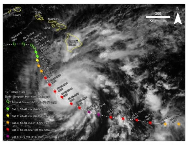
Image: The background image shows a visible satellite image of Hurricane Lane on August 22nd, 2018 when its eye was centered near the Hawaiian Islands. The white dashed line indicates the track of Lane, labeled with dates and times (UTC), and the color of the hurricane symbol indicates the strength of winds in the storm. (Credit: Nugent, et al. (2020))


