
Although a compact storm, hurricane Douglas in the Eastern Pacific is mighty, as it has become the season’s first major hurricane.
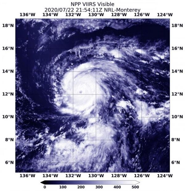
Although a compact storm, hurricane Douglas in the Eastern Pacific is mighty, as it has become the season’s first major hurricane. NASA-NOAA’s Suomi NPP satellite provided forecasters with an image of Douglas that showed development of an eye as it quickly intensified.
Early on July 22, Douglas was still a tropical storm. By 11 a.m. EDT (1500 UTC) it had strengthened into a hurricane. At 5:54 p.m. EDT (2154 UTC), the Visible Infrared Imaging Radiometer Suite (VIIRS) instrument aboard Suomi NPP revealed that the storm developed an eye. VIIRS showed that powerful bands of thunderstorms had circled the eye. Bands of thunderstorms were spiraling into the low-level center from the northern and southern quadrants. There was an indication that only a little dry air that earlier affected the storm, remained. What little dry air there was, stretched across the northern portion of the circulation, which was limiting the amount of deep convection wrapping around that part of the eye.
By July 23 at 5 a.m. EDT (0900 UTC), Douglas had rapidly intensified into a major hurricane. Maximum sustained winds have increased to near 120 mph (195 kph) with higher gusts. Douglas is a category 3 hurricane on the Saffir-Simpson Hurricane Wind Scale. Hurricane-force winds extend outward up to 25 miles (35 km) from the center and tropical-storm-force winds extend outward up to 105 miles (165 km).
Read more at NASA/Goddard Space Flight Center
Image: NASA-NOAA's Suomi NPP satellite provided forecasters with a visible image of Hurricane Douglas at 5:54 p.m. EDT (2154 UTC) as it moved through the Eastern Pacific Ocean. (Credit: NASA/NRL)


