
After Tropical Depression 07W formed close to the western Philippines, it moved away and strengthened into a tropical storm in the South China Sea.
After Tropical Depression 07W formed close to the western Philippines, it moved away and strengthened into a tropical storm in the South China Sea. NASA’s Terra satellite provided a look at the strength of the storms that make up the tropical cyclone.
On Aug. 9 at 11 p.m. EDT (Aug. 10 at 0300 UTC), Tropical Depression 07W formed near latitude 16.8 degrees north and longitude 118.3 degrees east, about 204 nautical miles northwest of Manila, Philippines.
When it formed it was close enough to the Philippines to generate warnings. Tropical cyclone wind signal #1 was posted for western portions of Ilocos Norte and Sur, La Union, western parts of Pangasinan, and northern part of Zambales. Those warnings were dropped by Aug. 10 as the system moved west and away from the Philippines.
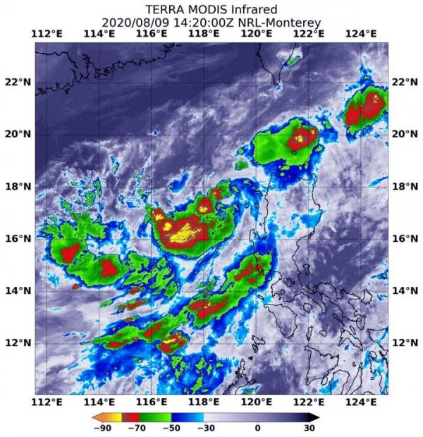
Infrared imagery gathered on Aug. 9 at 10:20 a.m. EDT (1420 UTC) was from the Moderate Resolution Imaging Spectroradiometer or MODIS instrument. MODIS flies aboard NASA’s Terra satellite. MODIS gathered temperature information about 07W’s cloud tops. Infrared data provides temperature information, and the strongest thunderstorms that reach high into the atmosphere have the coldest cloud top temperatures.
Read more at NASA/Goddard Space Flight Center
Image: On Aug. 9 at 10:20 a.m. EDT (1420 UTC), NASA's Terra satellite found the most powerful thunderstorms (yellow) were around Mekkhala's center of circulation and in several other areas, where temperatures were as cold as or colder than minus 80 degrees Fahrenheit (minus 62.2 Celsius). Those areas were surrounded by thunderstorms (red) slightly less high in the atmosphere, but still powerful rainmakers with cloud top temperatures as cold as or colder than minus 70 degrees Fahrenheit (minus 56.6 Celsius). (Credit: NASA/NRL)


