
NASA’s Terra satellite revealed that a wispy looking Tropical Depression 06W in the Northwestern Pacific Ocean was being battered by wind shear.
NASA’s Terra satellite revealed that a wispy looking Tropical Depression 06W in the Northwestern Pacific Ocean was being battered by wind shear. That wind shear is not expected to wane and the storm is expected to weaken.
Tropical Depression 06W formed two days ago on August 9 by 11 a.m. EDT (1500 UTC) near latitude 26.1 degrees north and longitude 147.6 east, about 250 nautical miles east-northeast of Iwo To Island, Japan. 06W briefly strengthened to a tropical storm by 5 p.m. EDT (2100 UTC) when maximum sustained winds reached 45 knots (52 mph/83 kph). By Aug. 10 at 11 a.m. EDT (1500 UTC) the storm had weakened back to tropical depression status.
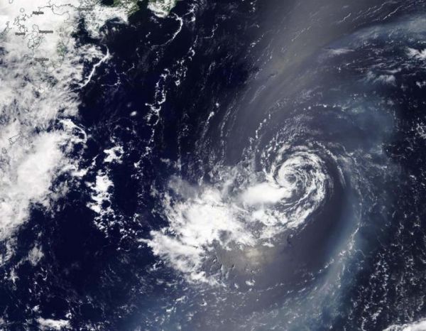
On Aug. 11, 2020, the Moderate Resolution Imaging Spectroradiometer or MODIS instrument that flies aboard NASA’s Terra satellite provided forecasters at the Joint Typhoon Warning Center in Honolulu, Hawaii with a visible image of Tropical Depression 06W. The image showed a ring of wispy clouds around a fully-exposed, well-defined, low-level center of circulation. It also showed that any precipitation and thunderstorms were pushed to the south-southwest of the center from vertical wind shear.
Read more at: NASA/Goddard Space Flight Center
On Aug. 11, 2020, NASA's Terra satellite provided a visible image of Tropical Depression 06W in the Northwestern Pacific Ocean that showed a ring of wispy clouds around a fully-exposed, well-defined, low-level center of circulation. It also showed that any precipitation and thunderstorms were pushed to the south-southwest of the center from vertical wind shear. Japan is located in the top left of this image. (Photo Credit: NASA/NRL)


