
Tropical Depression 10E weakened to a remnant low-pressure area in the Eastern Pacific Ocean.
Tropical Depression 10E weakened to a remnant low-pressure area in the Eastern Pacific Ocean. NASA’s Terra satellite observed the water vapor content in the storm.
At 5 p.m. EDT on Sunday, Aug. 16, NOAA’s National Hurricane Center noted that the depression had been devoid of organized deep convection for the previous 24 hours at at that time and lacked any convection. NHC therefore classified 10E as a post-tropical as a non-convective remnant low-pressure area.
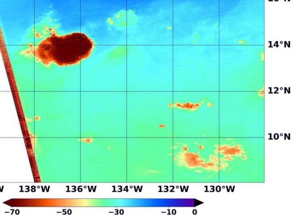
Water vapor analysis of tropical cyclones tells forecasters how much potential a storm has to develop. Water vapor releases latent heat as it condenses into liquid. That liquid becomes clouds and thunderstorms that make up a tropical cyclone. Temperature is important when trying to understand how strong storms can be. The higher the cloud tops, the colder and stronger the storms.
NASA’s Terra satellite passed over 10E’s remnants on Aug. 17 at 1:35 a.m. EDT (0535 UTC) and the Moderate Resolution Imaging Spectroradiometer or MODIS instrument gathered water vapor content and temperature information. MODIS data showed a small area of coldest cloud top temperature, that were as cold as or colder than minus 63 degrees Fahrenheit (minus 53 degrees Celsius).
Read more at NASA/Goddard Space Flight Center
Image: NASA's Terra satellite passed over 10E's remnants on Aug. 17 at 1:35 a.m. EDT (0535 UTC) in the Eastern Pacific Ocean. Terra found a small area of storms with highest concentrations of water vapor (brown) and coldest cloud top temperatures. (Credit: NASA/NRL)


