
NASA-NOAA’s Suomi NPP satellite kept an eye on Hurricane Genevieve overnight and provided infrared imagery to forecasters who were monitoring the storm’s strength, structure and size.
NASA-NOAA’s Suomi NPP satellite kept an eye on Hurricane Genevieve overnight and provided infrared imagery to forecasters who were monitoring the storm’s strength, structure and size. Because Genevieve is close to the coast of western Mexico, warnings and watches were still in effect.
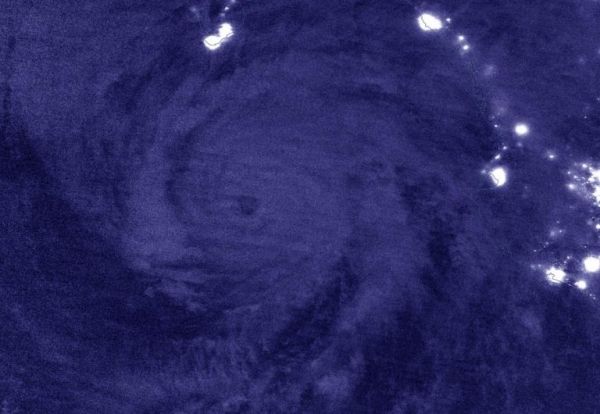
NASA’s Night-Time View of Genevieve
The Visible Infrared Imaging Radiometer Suite (VIIRS) instrument aboard Suomi NPP provided a nighttime image of Hurricane Genevieve on Aug. 18 at 8 p.m. EDT (Aug. 19 at 0000 UTC).The hurricane’s eye was still visible and well defined. It was surrounded by powerful thunderstorms, although deep convection is generally lacking over the southwestern portion of the circulation. The image was created using the NASA Worldview application.
Warnings and Watches on Aug. 19
NOAA’s National Hurricane Center issued a Hurricane Warning for the southern Baja California peninsula from Los Barriles to Todos Santos, Mexico. A Tropical Storm Warning is in effect for the west coast of the Baja California peninsula from north of Todos Santos to Cabo San Lazaro, and a Tropical Storm Watch is in effect for the east coast of the Baja California peninsula from Los Barriles to La Paz.
Read more at NASA / Goddard Space Flight Center
Image: NASA-NOAA’s Suomi NPP satellite passed the Eastern Pacific Ocean overnight on Aug. 18 at 8 p.m. EDT (Aug. 19 at 0000 UTC) and captured a nighttime image of Hurricane Genevieve off the coast of western Mexico. City lights from the coastal communities can be seen in the image. Credit: NASA Worldview, Earth Observing System Data and Information System (EOSDIS)


