
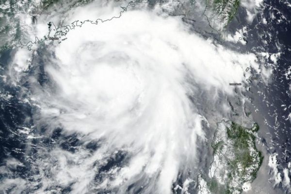
NASA-NOAA’s Suomi NPP satellite provided forecasters with a visible image of the landfall of Tropical Storm Higos on Aug. 18.
The Visible Infrared Imaging Radiometer Suite (VIIRS) instrument aboard Suomi NPP captured a visible image of Higos as it was making landfall in the Guangdong Province of China on Aug. 19 at 0000 UTC (Aug. 18 at 8 p.m. EDT). Higos came ashore about 18 miles (30 km) south of Macau City. The VIIRS image showed strong thunderstorms wrapped into the center of circulation, and bands of thunderstorms over the South China Sea at the time of the satellite overpass.
On Aug. 19 at 0300 UTC (Aug. 18 at 11 p.m. EDT), Tropical storm Higos had maximum sustained winds near 40 knots (46 mph/74 kph). It was centered about 67 nautical miles west of Hong Kong, China, near latitude 22.3 degrees north and longitude 113.0 degrees east. Higos was weakening and moving to the northwest.
Continue reading at NASA Goddard Space Flight Center
Image via NASA Goddard Space Flight Center


