
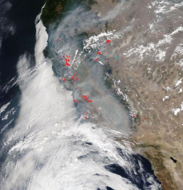
More than 650 wildfires are blazing in California after unprecedented lightning strikes, storms, and a heatwave that has set new records in the state and NASA’s Terra satellite captured the smoke-engulfed state on Aug. 24, 2020.
More than 650 wildfires are blazing in California after unprecedented lightning strikes, storms, and a heatwave that has set new records in the state and NASA’s Terra satellite captured the smoke-engulfed state on Aug. 24, 2020.
The two largest fires still burning the state are both named after the firefighting units that are battling them and the fact that both began with lightning strikes. The LNU Lightning Complex and the SCU Lightning Complex are both located in northern California. The LNU (Lake Napa Unit) Lightning Complex has burned 347,630 acres and is 21% contained and the SCU (Santa Clara Unit) Lightning Complex has consumed 343,965 acres and is 10% contained according to the CAL Fire website. These two fires are now second and third on the list of California’s largest wildfires.
Even discounting these fires there are still hundreds of other fires burning across the state as can be seen in this Terra satellite image taken on Aug. 24, 2020. Red dots litter the landscape designating areas which are most likely fires--so many fires, in fact, that the dots blur together and individual fire are no longer visible.
More insidious than the fires is the smoke that rises from the landscape. This aerosol image below shows not only California being affected by the heavy smoke as seen in the visible image above, but the smoke has traveled across much of the United States affecting areas from California all the way to Minnesota and Nebraska and air currents will undoubtedly carry the smoke across the entire U.S.
Read more at NASA/Goddard Space Flight Center
Image: NASA's Terra satellite shows a smoke-covered California on Aug. 24, 2020. (Credit: NASA Worldview)


