
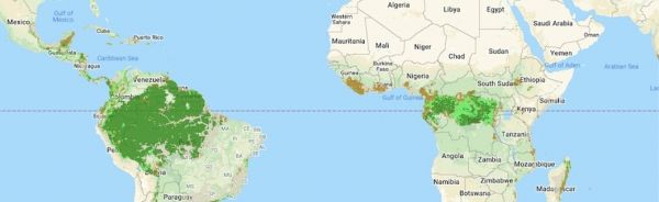
High-resolution NASA satellite data have made it possible for scientists to develop maps showing the "quality" of tropical forests.
Previous maps only focused on the size of a forest. These maps show forest quality as a single measurement, taking into account information like the height of trees, thickness of the forest canopy, and if logging, fire or a similar disturbance occurred.
"Now we have maps that show, not just where the forests are located, but the ecological quality of those forests," said lead author Andrew Hansen of Montana State University.
"That's important because it allows policy makers to prioritize forests that have the highest value in terms of biodiversity, carbon storage and water yield," Hansen said.
About half of the world's humid tropical forests could be considered of "high quality," according to the study published in the journal Nature Ecology & Evolution. The study was supported the United Nations Development Programme (UNDP), the Wildlife Conservation Society and other leading research institutions.
Continue reading at NASA
Image via NASA


