
By early September 2020, more than a quarter million acres had burned within the August Complex fire in Mendocino National Forest.
August 2020 brought a “lightning siege” in California that sparked a rash of wildfires across the state. By early September, nearly 14,000 lightning strikes had ignited 900 fires that have burned more than 1.5 million acres.
More than a quarter million of those acres burned within the August Complex, a fire located northwest of Willows, California, in Mendocino National Forest and adjacent areas. Smoke still streamed from the complex on September 1, when the Operational Land Imager (OLI) on Landsat 8 acquired these images. The first image is natural color and shows smoke blanketing numerous communities in Mendocino County.
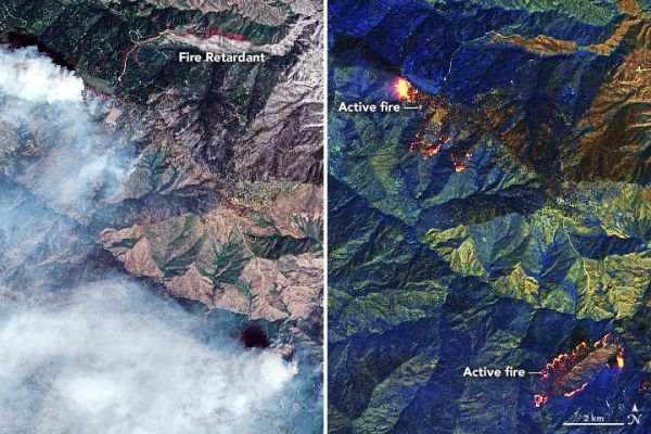
The image pair below shows detailed views of the fire’s northern extent, where strong winds on August 31 caused fire activity to pick up. Streaks of red are visible in the natural-color image (left) where aerial crews dropped fire retardant on the terrain to impede the spread of the fire. The right image was made from a combination of shortwave and near-infrared data (bands 7-6-5) to reveal the intensity of fire areas through the clouds. In this image, the hottest and most active parts of the fire front are yellow. The pink halo around the main fire area is caused by the hot gases emitted in the immediate vicinity of the fire front at the lower reaches of the fire plume. Previously burned areas are dark brown.
Continue reading at NASA Earth Observatory
Image via NASA Earth Observatory


