
Satellite data is helping scientists size up one of the most intense outbreaks of fire and smoke that Oregon and California have seen in decades.
Climate and fire scientists have long anticipated that fires in the U.S. West would grow larger, more intense, and more dangerous. But even the most experienced among them have been at a loss for words in describing the scope and intensity of the fires burning in West Coast states in September 2020.
Lightning initially triggered many of the fires, but it was unusual and extreme meteorological conditions that turned some of them into the worst conflagrations in the region in decades. Record-breaking air temperatures, periods of unusually dry air, and blasts of fierce winds—on top of serious drought in some areas—led fires to ravage forests and loft vast plumes of smoke to rarely seen heights.
“We had a perfect storm of meteorological factors come together that encouraged extreme burning,” said Vincent Ambrosia, the associate program manager for wildfire research in NASA’s Earth Applied Sciences Program. “That was layered on top of shifting climate patterns—a long term drying and warming of both the air and vegetation—that is contributing to the growing trend we are seeing toward larger, higher-intensity fires in the U.S. West.”
Continue reading at NASA Earth Observatory
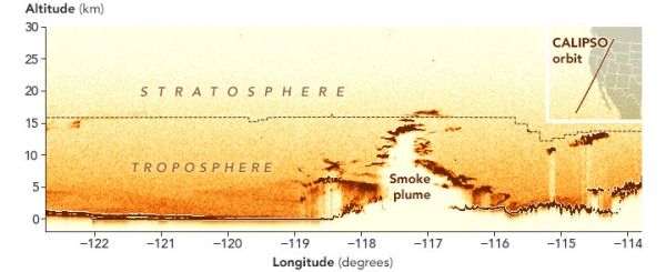
Image via NASA Earth Observatory


