
NASA’s Aqua satellite and the NASA-NOAA Suomi NPP satellite provided views of the strength, extent and rainfall potential as Hurricane Sally was making landfall during the morning hours of Sept. 16.
NASA’s Aqua satellite and the NASA-NOAA Suomi NPP satellite provided views of the strength, extent and rainfall potential as Hurricane Sally was making landfall during the morning hours of Sept. 16.
Watches and Warnings
NOAA’s National Hurricane Center has many warnings and watches in place today, Sept. 16. A Storm Surge Warning is in effect from Dauphin Island, Alabama to the Walton/Bay County Line, Florida. A Hurricane Warning is in effect for the Mississippi/Alabama border to the Okaloosa/Walton County line, Florida.
A Tropical Storm Warning is in effect for east of the Okaloosa/Walton County line, Florida to Indian Pass, Florida and from the Mississippi/Alabama border to the Mouth of the Pearl River.
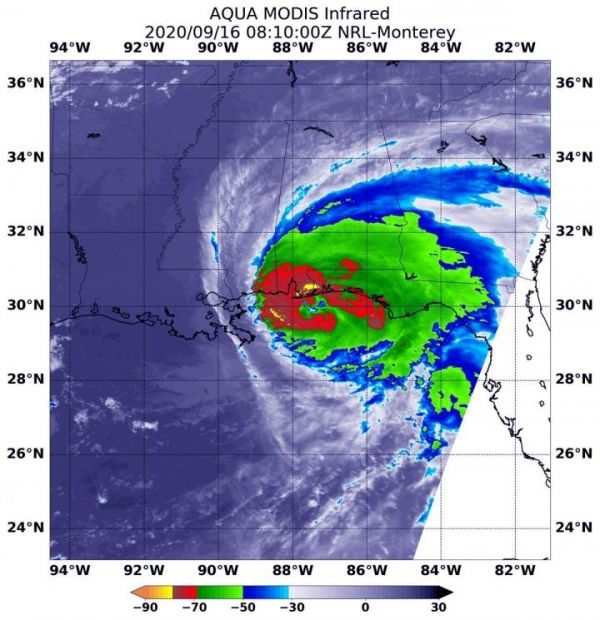
NASA’s Infrared Data Reveals Heavy Rainmakers
Tropical cyclones and hurricanes are made up of hundreds of thunderstorms, and infrared data can show where the strongest storms are located. That is because infrared data provides temperature information, and the strongest thunderstorms that reach highest into the atmosphere have the coldest cloud top temperatures.
Read more at NASA/Goddard Space Flight Center
Image: On Sept. 16 at 4:10 a.m. EDT (0810 UTC) NASA's Aqua satellite used infrared light to analyze the strength of storms within Sally. Aqua found the most powerful thunderstorms were north of the eye where cloud top temperatures were as cold as minus 80F/minus 62.2C (yellow) Strong storms with cloud top temperatures as cold as minus 70F/minus 56.6C (red) circled the most powerful storms. (Credit: NASA/NRL)


