
Powerful storms with heavy rainmaking capabilities appeared over the coast of central Vietnam in NASA provided infrared imagery on Sept. 17.
Powerful storms with heavy rainmaking capabilities appeared over the coast of central Vietnam in NASA provided infrared imagery on Sept. 17.
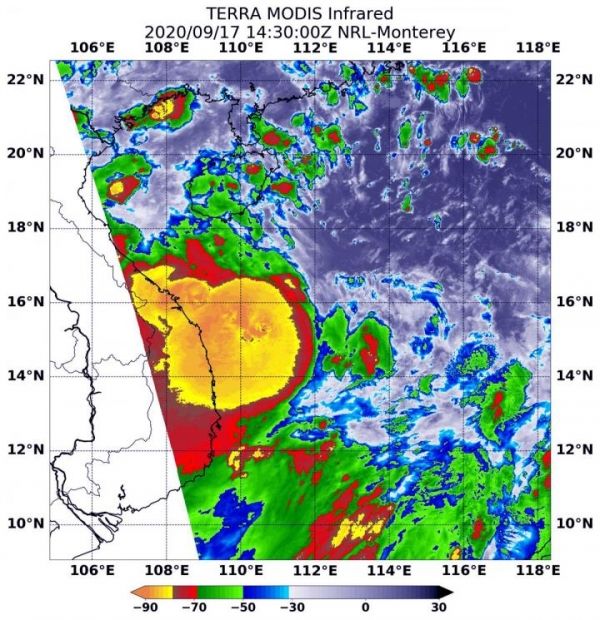
NASA’s Infrared Data Reveals Heavy Rainmakers
Tropical cyclones are made up of hundreds of thunderstorms, and infrared data can show where the strongest storms are located. That is because infrared data provides temperature information, and the strongest thunderstorms that reach highest into the atmosphere have the coldest cloud top temperatures.
On Sept. 17 at 10:30 a.m. EDT (1430 UTC), the Moderate Imaging Spectroradiometer or MODIS instrument that flies aboard NASA’s Aqua satellite revealed a large area of the most powerful thunderstorms (yellow) were around Noul’s center where cloud top temperatures were as cold as minus 80 degrees Fahrenheit (minus 62.2 Celsius). Those storms were mostly in the western quadrant of the storm and over the central Vietnam coast and they extended over the South China Sea. Strong storms with cloud top temperatures as cold as minus 70 degrees Fahrenheit (minus 56.6. degrees Celsius) surrounded the center and were generating large amounts of rain.
Read more at NASA/Goddard Space Flight Center
Image: On Sept. 17 at 10:30 a.m. EDT (1430 UTC) the MODIS instrument that flies aboard NASA's Aqua satellite revealed a large area of the most powerful thunderstorms (yellow) were around Noul's center where cloud top temperatures were as cold as minus 80 degrees Fahrenheit (minus 62.2 Celsius). Those storms were over the central Vietnam coast and extended over the South China Sea. Strong storms (red) with cloud top temperatures as cold as minus 70 degrees Fahrenheit (minus 56.6. degrees Celsius) surrounded the center and were generating large amounts of rain. (Credit: NASA/NRL)


