
An early morning infrared image of Hurricane Teddy taken from NASA-NOAA’s Suomi NPP satellite shows the proximity of the strengthening hurricane to the Lesser Antilles island chain and Puerto Rico. Teddy is a major hurricane on the Saffir-Simpson Hurricane Wind Scale.
An early morning infrared image of Hurricane Teddy taken from NASA-NOAA’s Suomi NPP satellite shows the proximity of the strengthening hurricane to the Lesser Antilles island chain and Puerto Rico. Teddy is a major hurricane on the Saffir-Simpson Hurricane Wind Scale.
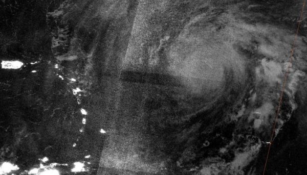
NASA-NOAA’s Suomi NPP satellite passed the North Atlantic Ocean overnight on Sept. 17 at 12:40 a.m. EDT (0440 UTC). The Visible Infrared Imaging Radiometer Suite (VIIRS) instrument aboard Suomi NPP provided a nighttime image of Hurricane Teddy. Puerto Rico and the Lesser Antilles can be seen lit up by night lights to the west in the image. The Lesser Antilles a group of islands that frame the eastern side of the Caribbean Sea.
The image was created using the NASA Worldview application at NASA’s Goddard Space Flight Center in Greenbelt, Md.
By 11 a.m. EDT infrared imagery revealed Teddy’s satellite appearance had steadily developed. There is now a ragged warming eye surrounded by a ring of convection with cloud tops colder than minus 76 degrees Fahrenheit/minus 60 degrees Celsius.
Read more at NASA/Goddard Space Flight Center
Image: NASA-NOAA's Suomi NPP satellite passed the North Atlantic Ocean overnight on Sept. 17 at 12:40 a.m. EDT (0440 UTC) and captured a nighttime image of Hurricane Teddy. Puerto Rico and the Lesser Antilles can be seen lit up to the west (left). (Credit: NASA Worldview, Earth Observing System Data and Information System (EOSDIS))


