
Using a NASA satellite rainfall product that incorporates data from satellites and observations, NASA estimated Hurricane Teddy’s rainfall rates as it approaches Bermuda on Sept. 21.
Using a NASA satellite rainfall product that incorporates data from satellites and observations, NASA estimated Hurricane Teddy’s rainfall rates as it approaches Bermuda on Sept. 21. Teddy is a large hurricane and growing. It is also churning up seas all the way to the U.S. and Canadian coastlines.
Watches and Warnings on Sept. 21
NOAA’s National Hurricane Center posted a Tropical Storm Warning for Bermuda and a Tropical Storm Watch is in effect from Lower East Pubnico to Main-a-Dieu, Nova Scotia, Canada.
Teddy’s Status on Sept. 21
At 11 a.m. EDT (1500 UTC), the center of Hurricane Teddy was located near latitude 31.1 degrees north and longitude 62.7 degrees west. That is about 150 miles (240 km) east-southeast of Bermuda and about 935 miles (1,500 km) south of Halifax, Nova Scotia, Canada.
Teddy was moving toward the north-northeast near 14 mph (22 kph), and this motion is expected to continue today, followed by a turn toward the north overnight and north-northwest on Tuesday. Maximum sustained winds were near 90 mph (150 kph) with higher gusts. Teddy is a large hurricane. Hurricane-force winds extend outward up to 80 miles (130 km) from the center and tropical-storm-force winds extend outward up to 230 miles (370 km).
Read more at NASA/Goddard Space Flight Center
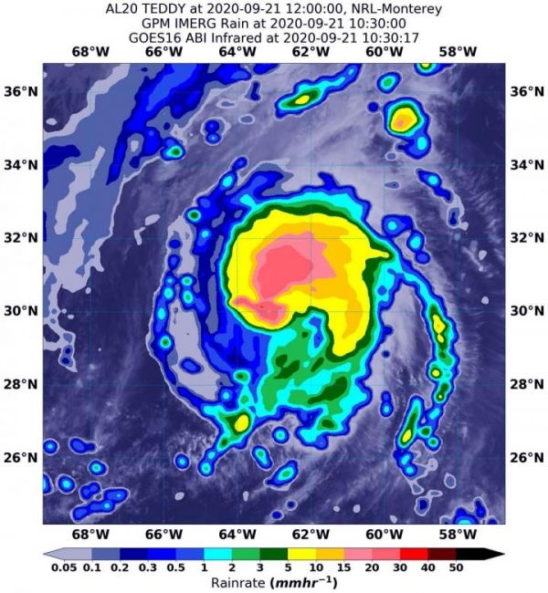
Image: On Sept. 21 at 6:30 a.m. EDT (1030 UTC), NASA's IMERG estimated Hurricane Teddy was generating as much as 30 mm/1.18 inches of rain (dark pink) around the center of circulation. Rainfall throughout most of the rest of the storm was occurring between 5 and 15 mm (0.2 to 0.6 inches/yellow and green colors) per hour. The rainfall data was overlaid on infrared imagery from NOAA's GOES-16 satellite. (Credit: NASA/NOAA/NRL)


