
NASA infrared imagery revealed that Hurricane Marie is rapidly growing stronger and more powerful.
NASA infrared imagery revealed that Hurricane Marie is rapidly growing stronger and more powerful. Infrared imagery revealed that powerful thunderstorms circled the eye of the hurricane as it moved through the Eastern Pacific Ocean.
NOAA’s National Hurricane Center (NHC) expects Marie to become a major hurricane late on Oct. 1.
Infrared Imagery Reveals a More Powerful Marie
One of the ways NASA researches tropical cyclones is using infrared data that provides temperature information. Cloud top temperatures identify where the strongest storms are located. The stronger the storms, the higher they extend into the troposphere, and the colder the cloud top temperatures.
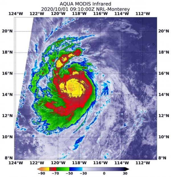
On Oct. 1 at 4:10 a.m. EDT (0910 UTC) NASA’s Aqua satellite analyzed the storm using the Moderate Resolution Imaging Spectroradiometer or MODIS instrument. Hurricane Marie’s cloud top temperatures and found strongest storms were around Marie’s center of circulation. Temperatures in those areas were as cold as minus 80 degrees Fahrenheit (minus 62.2 Celsius). Strong storms with cloud top temperatures as cold as minus 70 degrees Fahrenheit (minus 56.6. degrees Celsius) surrounded the center.
Read more at NASA/Goddard Space Flight Center
Image: On Oct. 1 at 4:10 a.m. EDT (0910 UTC) NASA's Aqua satellite analyzed Hurricane Marie's cloud top temperatures and found strongest storms (yellow) were around Marie's center of circulation. Temperatures in those areas were as cold as minus 80 degrees Fahrenheit (minus 62.2 Celsius). Strong storms with cloud top temperatures as cold as minus 70 degrees (red) Fahrenheit (minus 56.6. degrees Celsius) surrounded the center. (Credit: NASA/NRL)


