
Infrared imagery from NASA’s Aqua satellite revealed that dry air is eroding Tropical Storm Norbert, located off the coast of southwestern Mexico.
Infrared imagery from NASA’s Aqua satellite revealed that dry air is eroding Tropical Storm Norbert, located off the coast of southwestern Mexico.
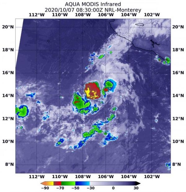
On Oct. 7 at 4:30 a.m. EDT (0830 UTC), the Moderate Resolution Imaging Spectroradiometer or MODIS instrument aboard NASA’s Aqua satellite gathered temperature information about Norbert’s cloud tops. Infrared data provides temperature information, and the strongest thunderstorms that reach high into the atmosphere have the coldest cloud top temperatures.
Dry air suppresses the development of thunderstorms that need warm, moist air to form. Dry air saps the moisture. Tropical cyclones consist of hundreds of thunderstorms. When their development is limited by environmental factors, they have difficulty strengthening and often weaken. The MODIS image showed fragmentation of thunderstorms around Norbert’s center as dry air affected development.
Read more at: NASA/Goddard Space Flight Center
On Oct. 7 at 4:30 a.m. EDT (0830 UTC), the MODIS instrument aboard NASA's Aqua satellite gathered temperature information about Norbert's cloud tops. MODIS found a limited area of powerful thunderstorms (red) around the center where temperatures were as cold as or colder than minus 70 degrees Fahrenheit (minus 56.6 Celsius). Dry air around it was sapping other thunderstorms from developing. (Photo Credit: NASA/NRL)


