
NASA’s satellite rainfall product that incorporates data from satellites and observations found that Hurricane Delta was bringing along heavy rainfall as it headed to the U.S. Gulf Coast on Oct. 9.
NASA’s satellite rainfall product that incorporates data from satellites and observations found that Hurricane Delta was bringing along heavy rainfall as it headed to the U.S. Gulf Coast on Oct. 9.
Warnings and Watches in Effect on Oct. 9
There are many warnings in effect, as Delta approaches the U.S. Gulf coast. A Storm Surge Warning is in effect from High Island, Texas to Mouth of the Pearl River, Louisiana including Calcasieu Lake, Vermilion Bay, and Lake Borgne.
A Hurricane Warning is in effect from High Island, Texas to Morgan City, Louisiana. A Tropical Storm Warning is in effect from west of High Island to Sargent, Texas and east of Morgan City, Louisiana to the mouth of the Pearl River, including New Orleans and Lake Pontchartrain and Lake Maurepas.
Read more at NASA/Goddard Space Flight Center
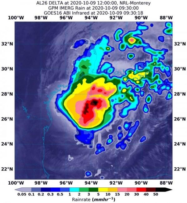
Image: On Oct. 9 at 5:30 a.m. EDT (0930 UTC), NASA's IMERG estimated Delta was generating as much as 50 mm(~2 inches of rain [dark red]) around the center of circulation. Rainfall rates in storms surrounding those areas of heaviest rainfall (green, pink, red) were estimated as falling at a rate between 10 and 40 mm (0.4 to 1.6 inches) per hour. The rainfall data was overlaid on infrared imagery from NOAA's GOES-16 satellite. (Credit: NASA/NOAA/NRL)


