
It will be the fifth storm to hit Louisiana this year, and the eleventh to hit the continental United States.
For the fifth time this year, a named tropical storm or hurricane is going to make landfall in Louisiana. For the eleventh time in 2020, a named storm is going to hit the continental United States; according to meteorologist Jeff Masters, that is the most since nine made landfall in 1916. For just the sixth time in 170 years, a hurricane is going to come ashore in the U.S. on or after October 28.
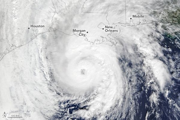
A natural-color image of Hurricane Zeta (above) was acquired in the late morning on October 28, 2020, by the Moderate Resolution Imaging Spectroradiometer (MODIS) on NASA’s Terra satellite. Cameras mounted on the International Space Station captured video footage of the storm (below) just before 1 p.m. that day.
At 1 p.m. Central Daylight Time on October 28, the National Hurricane Center (NHC) reported that the center of Zeta was about 155 miles (255 kilometers) south-southwest of New Orleans. The category 2 storm had maximum sustained winds of 100 miles (155 kilometers) per hour, with higher gusts. Hurricane-force winds stretched as far as 35 miles (55 kilometers) from the center, and tropical storm-force winds extended to 150 miles (240 kilometers).
Continue reading at NASA Earth Observatory
Image via NASA Earth Observatory


