
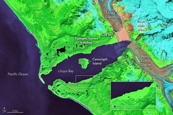
One of the tallest tsunami waves known to science slammed this Alaskan bay in 1958.
When he first encountered Lituya Bay in 1786, the French explorer Jean-François de Galaup La Pérouse was intrigued by an odd line in the forests that surrounded the narrow fjord in southeastern Alaska. It was as though the forests “had been cut cleanly with a razor blade,” he noted in his log.
It was the first clue that the seemingly placid, protected waters of the bay had a more destructive side. Another came when he dispatched three small boats to measure the depth of the water near the entrance of the bay. Despite the weather being calm, two of the three boats capsized after being drawn into roiling tidal currents that had been amplified by the fjord’s narrow shape. Twenty-six men lost their lives, their remains never to be found. It was in their honor that the lone island in the bay was given the name Cenotaph, a Greek word meaning “empty tomb.”
The name turned out to be all too fitting. In 1899, an earthquake triggered a giant wave that destroyed a native village and drowned 5 people on the island. Another tsunami wave hit in 1936. But it was in 1958 that Lituya Bay’s unpredictable waters reared up in truly apocalyptic fashion. After a 7.8 earthquake throttled the nearby Fairweather Fault, a rockslide sent 90 million tons of rock plunging into the bay—an amount equivalent to 8 million dump truck loads.
Continue reading at NASA Earth Observatory
Image via NASA Earth Observatory


